Saturday, September 04, 2010
A Western Kentucky Tour
 Beverly and I were thinking of things to do over the long Labor Day weekend. We were looking over the map of Kentucky vineyards and noticed several in western Kentucky. We decided we'd call my mother and sister in Madisonville and find out their plans. They had no plans so a wine tasting tour it was. The tour expanded when we elected include visits to the Clement Mineral Museum in Marion and the Camp Breckinridge Museum near Morganfield. The Google map of our route is available.
Bill and Susan, my Mother, and Beverly and I started the day at the Ben E. Clement Mineral Museum. Marion is in Crittenden County and is in the heart of Kentucky's flourspar district. Mr. Clement accumulated an impressive collection of local and international mineral specimens many of which have been documented and borrowed by such institutions as the Smithsonian. The collection is now curated by Mr. Clement's family and is open to the public.
 |  |
 |  |
From the mineral museum, we went to the James D. Veach Museum and Arts Center at Camp Breckinridge. Camp Breckinridge was built at the start of WWII and was an infantry training center. After WWII, the 101st Airborne was reactivated there to train soldiers for the Korean War. Early in WWII, German prisoners from the North African campaign were incarcerated at the camp. One of the prisoners, Daniel Mayer, began painting European landscapes on the plywood panels comprising the walls of the ballroom in the NCO club. The facility later became the Officers Club. He painted scenes from memory and from postcards he received from home. Unfortunately, Daniel contracted pneumonia before the end of the war and never return to the countryside for which he longed. The panels have recently been restored.

We decided to stop at the Feed Mill Restaurant for a late (2:30ish) lunch. This restaurant on Hwy 60 serves traditional country fare (fried chicken, green beans, mashed potatoes), cajun, steaks, and includes a full bar (looking forward to our wine tasting, we didn't partake). We had an appetizer of fried pickles and ordered etouffe'e, red beans and rice, fried chicken, fried catfish, and jambalaya. It was all good.

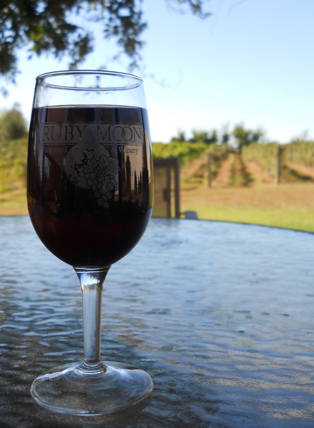
We arrived in due time at the Ruby Moon Vineyard and Winery near Henderson. The tasting room was busy (a good sign). We tried the estate wines: Chambourcin (dry) and Traiminette (semi-dry and fruity). We had the Peach (semi-sweet) and Razzle Dazzle Raspberry (sweet). These fruit wines were made with locally grown fruit ("across the road"). Beverly and I purchased a bottle each of the Traiminette and Peach wines. For relaxing on the patio under the pergola covered by a wisteria, I choose a glass of the Chambourcin and Beverly had the Traiminette. To accompany our wine, I got a small block of garden herb havarti cheese and crackers. The cheese is from Kenny's Farmhouse Cheese crafted in Barren County and was a good accompaniment to the wines.
 |  |
All in all, it was a wonderful day for tour along Kentucky's rural byways.
Wednesday, June 23, 2010
First day in London

Sent via BlackBerry by AT&T
Tuesday, June 08, 2010
Aboard ship

Sent via BlackBerry by AT&T
Monday, May 31, 2010
Out and About With Nowhere To Go
 This long Memorial Day weekend we took two tours, northerly and southeasterly.
On Saturday, for the northern trip, we decided to take the advice of Guy Fieri of Diners, Drive-ins and Dives and try a restaurant in Bellevue, Kentucky called Virgil's Cafe. From Frankfort, we headed east to Georgetown on 460. The intent was to take 62 to Cynthiana, but somehow we made a wrong turn. No matter, we ended up on 25 north and took 32 east to Cynthiana and went through Sadieville. The town was founded where the Southern Railway crosses Eagle Creek and was a major shipping point for mules. From Cynthiana, we headed north on 27 and I-471 to Fairfield Avenue in Bellevue where we found Virgil's.
I guess you could describe the decor as nuvo-stately. Chairs, tables, glasses, and all have been rounded up, restored, and reused. You'll note the table in the photo incorporates two different chair styles. Originally, I wanted to get the chicken etouffee with homemade andouille sausage (featured on Triple-D). However, it was a late lunch and that looked like a prodigious amount of food so I ordered the cubano sandwich (roast pork, mustard, pickles, ham, and swiss on homemade bread). Beverly had the Croque Madame (ham and cheese sandwich with mustard mornay sauce topped with an over easy egg). Both were excellent and Virgil's is definitely worth going back.

We stopped for a short stroll in the riverfront part at Bellevue and watched the stern paddle wheel Belle of Cincinnati head up river on an afternoon excursion. The Mount Adams neighborhood of Cincinnati is across the river. We followed Fairview Avenue west to Highway 8 and then to 42 west to 127 south. At Owenton, we took 22 west to Gratz, 389 south to Lockport. At Lockport, we pick up the Fallis-Gest road that takes us by the Kentucky River Wildlife Management area. From there it was on to 561, 421, and home.

Nicholasville: If you own your own railroad, you can have trains in your front yard.
 On Sunday, we started out maybe a bit more randomly than usual. We went to the Buckley Wildlife Sanctuary. This sanctuary is a working farm and outdoor laboratory managed especially for birding by the National Audubon Society. From there, Beverly said she wanted to go to Hall's on the River. We took McCracken Pike to Versailles then 33 south to 169. On 169 we stopped at Boyd Orchard to check on peaches (too early) and found strawberries that smelled and tasted like real strawberries (you know, not like the berries from major grocery store chains). Our raspberries aren't even close yet, but yesterday was the first day they had them. We continued southeast down 169 to Keene (the hotel is serving breakfast) and Nicholasville. We detoured down 1981 to Chrisman Mill Vinyards. It is closed on Sundays, but we know where it is for another Saturday destination.
 We retraced our route to 169 and then crossed the Kentucky River at the Valley View Ferry. We continued to Richmond and then north on 25/421. When we got to the intersection with 627 at Whitehall, we initially thought we'd visit the Jean Farris Winery (sure to be open on Sunday). Before we got there, however, we began thinking of the fried banana peppers at Hall's and turned around.
Now we know the whereabouts of two more wineries and are accumulating more possible destinations.
Next weekend, it's off to Madisonville for my niece's wedding. And then, we are London, England bound. I know the email updates work. I don't know if I'll get WiFi and multimedia services there on my Blackberry, but we'll see.
Sunday, May 02, 2010
Places the GPS can't find
There are places you can only find with a GPS if you are actually there. OK, not really, they exist on paper maps and you can find them by working out the latitude and longitude and then programming the GPS to go there. With a GPS, you can't "GO TO" a place name (if it's not in the database) or an intersection (if there are too many digits in the highway numbers or it's just a name--Happy Ridge Rd--near a place it can't find). And, that's kind of nice. First, it satisfies my academic requirement that if you have a GPS, don't venture forth without a map. Every GPS and map are compromises between what is known and what can be displayed conveniently, this is scale dependence. The more you zoom out, the GPS display shows fewer and fewer details until you are often located on a blank screen with an interstate somewhere off to the east and no visible means to route there.
 Second, it is gratifying to know there are places you just have to go to find hidden scenic and historic gems. Oh, you can google them after the fact, but unless you already know it's there, you can't find it. Try googling "19th century inns of central Kentucky." You get a bunch of B&B stuff, but nothing about the Keene Springs Hotel. I'll give you that it doesn't look like the site is operated as an inn or B&B. The sign out front advertises "Home Cooking, Thursday-Saturday 6pm-9pm, Private Parties, Catering, 859-881-1234." Googling Keene Springs Inn hits paydirt. I like it that the menu posted for June 25-27 doesn't say what year. Beverly and I will have to try it on a Saturday. Apparently, there is a ghost legend, but beyond some woo-woo about "investigations" conducted by local ghost hunters, there is nothing available about the ghost whose story would certainly be more interesting than night vision goggles.
 Last weekend, when I drove by the Keene Springs Inn, started with the intent to drive from Cove Springs Park in Frankfort to Natural Bridge State Resort Park. I never made it. Having been to Natural Bridge, I got side tracked to the Pilot Knob nature preserve (Google map). I wasn't prepared to hike to the top of the Knob and so took a short walk in the woods to the millstone quarry. From there I started back along Hwy 15 and drove past Eskippakithiki, the Indian Old Fields. (Go to the Kentucky Historical Society and search for marker 1274). In addition to history, the physiography of Kentucky is very apparent here. In this view, the contrast between the flatter, rolling terrain of the Bluegrass regions and the hilly Knobs and escarpment is evident.
Anyway, I took 15 to Winchester, then 627 to Boonesborough and over to 421/25 at White Hall. To get around Lexington, I took Jacks Creek Rd and stopped by Raven Run Nature Preserve. I worked my way over to 169 and took that through Nicholasville to 33 and on into Versailles. From there, I took McCracken Pike past Woodford Reserve and back to Frankfort.
This weekend, I started from the Kentucky River Wildlife Management Area in Henry County. I headed west on the Gest-Fallis Road to Lockport then took 398 north to Drennon Springs. Drennon Springs is the site of one of the earliest stations in Kentucky and it appears on Filson's 1784 map, "This map of Kentucke". None of the historic markers that mention Drennon Springs seem to be anywhere near the community itself. At Drennon Springs, I headed south on 1360 through Franklinton to 22. At Bethlehem, I took 573 to 561 and then to 421 and home.
Folks, there's plenty to explore. And now, like the Keene Springs Inn, I'm finding places that need revisiting.
Tuesday, April 13, 2010
Getting ready for England

Sent via BlackBerry by AT&T
Sunday, April 11, 2010
Anglin Falls

Beverly hopped in the car today thinking I had a plan. As we started out of the driveway she asked where are we going? "I don't know." Earlier in the week, Paula said something about Anglin Falls. I had looked it up and Anglin Falls outside of Berea became our destination.
Keeping to our no interstates rule, we routed through Harrodsburg, Danville, Lancaster, and Berea: Google Map.
The trail was short (about 1.25 miles round trip). Mostly it was easy to moderately strenuous. As we were leaving, a young woman was attempting to free climb the face of a boulder, but there was nothing technical or intimidating about the trail anywhere along it. The last 150 yards or so it became significantly steeper and more rocky. A bit of scrambling over some fallen boulders and we made our way around and behind the falls where not much water was actually falling today. I hope that's not a sign of a dry summer. I guess you could call this picture "Find Beverly". She's sitting and enjoying the sun and scenery.
There were lots of wildflowers. Some of the highlights were: Jack-in-the-pulpit, False Rue Anemone, Violets, Trillium, Dutchman's-breeches, and Wood Poppy. I didn't have my wildflower book and misidentified the Rue Anemone. After admitting I couldn't claim even amateur status a helpful couple on the trail straightened me out. (I remember spring excursions around western Kentucky with my Dad who seemed to know every wildflower. I picked up some, but not enough.)
I am posting GPS logs of trails I've taken at GPSies.com. Again, I have to force Google Maps to take our back roads route. The trail map for Anglin Falls may help you find it.
- Anglin Falls SNP: N37.49152 W84.22771 (approximate entrance to preserve)
- Anglin Falls PKG: N37.49334 W84.22624 (parking area near trail head)
- Anglin Falls: N37.49796 W84.21654 (approximate location of falls)
![]()
